Friday, February 17, 2012

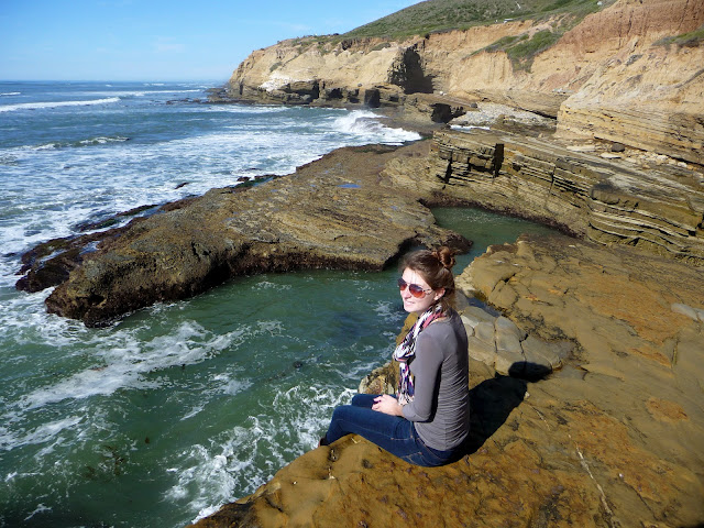
Sunset Cliffs, Point Loma

Laken and I wanted a good sister day so we headed down to Point Loma for some tide pool exploring. We went on super bowl sunday and had all the cliffs to ourselves since everyone was watching the game, it was great. 

This is a super easy location to get to, just look up directions for how to get to Sunset Cliffs Natural Park. Once you have entered the park, take the first right turn and this will take you down to the cliffs.

The views are just spectacular; in the distance you can see the Coronado Islands- which are actually part of Mexico. 


A view from the top shows some rather large sea caves. 


Erosion wears away at the hill sides and creates some pretty crazy looking cliffs here.


Down at the upper tide pools, on these upper levels you can find many different hermint, sand, and soft shell crabs; and the occasional little fish!


Natural steps leading to the lower pools.


Some little hermit crabs feasting on a kelp bulb.


This was one of the many artillery stations that lined the coast during World War II. With Pearl Harbor wiped out after the December 7th attack, nothing stood between the U.S. mainland and Japan so the whole of the west coast was on high alert.


On the upper cliffs near the artillery station, note the Coronado Islands in the background.


The original Point Loma lighthouse, it no longer services and the newer house is down near the tide pools right on the point. It's fun to walk around the old one and check out the tiny living spaces inside. A view from the top also boasts and incredible view looking towards down town San Diego.


This is a great half day trip and offers an amazing array of sights in a small location. Even better, the cliffs are minutes from down town, so make the quick drive over and grab lunch out!

Tuesday, February 7, 2012

Hidden Meadow Caves

Max and I had not seen Andrew since getting back from our Great Pacific Northwest Roadtrip and so we wanted to go try a new hike. Andrew had heard of some caves up in Lawrence Welk from someone at school, but we had very vague directions. After some searching we found directions that worked well enough for us and we headed out. 

Here are the directions we used: Exit the I-15 off the Mountain Meadow/Deer Springs exit heading east on Mountain Meadow. Take a left in about a mile to stay on Mountain Meadow Road, then another left onto Meadow Glen Way East, and finally another left to Meadow Glen Way West. Park near the lower hill and continue towards the fence.

You will start in a residential area and head towards the trail head. It appears to be blocked by a fence, but if you walk to the left side of the gate you can easily walk around and onto the trail. The beginning of the trail is a rather easy walk since it is maintained by the water department.


The trail will begin to incline down and there will be a thin strip on concrete heading straight downhill towards the freeway. There are some cave entrances immediately to the left of the start of the concrete strip; but we found that without proper gear these were much harder to get into and rather dangerous. 


Continue all the way to the end of the concrete strip to the second manhole cover. This second one will be built above ground and to the left you will see a cascade of smaller rocks leading into the ravine. This is where you should start heading down. 


Before I go into detail WE ARE BY NO MEANS PROPER CAVE EXPLORERS. Cave exploring is very dangerous and we went on this hike knowing and understanding the risks and went as prepared as possible. With that being said, when you drop down to the ravine there will be a very large overturned boulder to your right. The entrance to the cave is on the other side and will look like this.


Unfortunately there is lots of graffiti everywhere and lots of trash, but if you can look past that once you get into the caves are quite spectacular. I'm not really one to go into a cave since I get claustrophobic while snorkeling- so this put the awesome cave buddy program immediately into effect. 


Always while exploring caves you should call someone and let them know where you will be going; so while Max and Andrew ventured into the caves I waited up top with extra gear. The next few pictures are some they took while in the caves. These caves were caused over time by erosion, so naturally there are many areas where the creek runs through out the caves which in turn makes it very cold. 


There are also rumored to be some Native American rock paintings at the bottom of the canyon, so after getting out of the caves we continued down to the bottom of the canyon. There are many beautiful oak trees, lots of large boulders to climb over, and the meandering creek.


Spied these little gems on the side of a mossy boulder and decided they would have to be relocated to our garden! 

Just some friendly reminders to bring along rope, flashlights, sweatshirt (it's cold in the caves), and let someone know where you're going! Be on the look out for rattlesnakes and especially careful of poison oak as it is plentiful in the area.

Overall we found this hike very enjoyable once you get past the graffiti and miscellaneous trash. Finding caves to explore is a rare treat in Southern California and they were rather easy to get to; we did this all as a half day hike and went to the beach afterwards to wash off the cave grime!

Thanks for reading! More to come soon!